Pages

Tuesday, September 9, 2014

8/23/14 Saturday. Highs and Lows of the John Muir Trail. 8/24/14 Sunday. Devil's Postpile, Red's Meadow, YARTing Into Mammoth & Finished (for the year!)

8/23/14  11 miles.
Once again we woke to frost on our tents. Breakfasting in the sun we tried to lay out our wet tent flys to dry before packing them up.  We're both exhausted from the steep trail yesterday.  The JMT (John Muir Trail) usually follows the PCT except when it dips down beside many of the lakes set in gorgeous granite bowls.  To access the lakes the trail drops down off the peaks then back up again to descend into other lake basins.  We chose to go this route because of the scenery but it does have a price....exhaustion!  But I wouldn't want to miss this for the world!
Leaving Emerald Lake we ascended to Ruby Lake pictured here, the peaks reflected in the mirrored surface.
Then we descended quite a way to Garnet Lake whose islands reminded me of a smaller version of Thousand Island Lake from yesterday. Banner Peak is  in the background.
I took this photo of the lake through the log bridge across the lake outlet where we stopped to filter water and have a snack. We resumed the trail and followed it up above the left side of the lake.
Once we reached the top we descended through this rocky slope  to the meadow below which was dry this year. Down, down through forested mountains I caught views through the trees of soaring peaks and small glaciers shining white against them.  A four point buck startled and ran down the trail from us, Peggy saw him as he looked back over his shoulder at us.   These gentians and black eyed susan grew lushly by the trail where rain had recently watered them.
Finally we arrived at Shadow Lake where we'd planned a lunch stop with extended rest time.  The sun was warm but it was breezy by the lake.  There were more people on the JMT than we usually see on the PCT, I need to get used to the crowds.  After our noon rest we needed to do more miles, that would put us into position for getting to Red's Meadow tomorrow.  As we left Shadow Lake the trail immediately started switchbacks up the steep sides of the lake.  Many times Peggy and I could talk to each other as she passed just above me on the next switchback.  It took a good 40 minutes to climb the 700 feet up!  Just a short descent and we were passing Rosalie Lake,  wonderfully blue in the sun.  A young man was fishing for trout having just caught and released one.  
Rosalie Lake 
After climbing out of Rosalie's basin we passed shallow Gladys Lake just off trail in the trees.
No one was around and we both wanted to stop to camp here but we also wanted to arrive at Red's Meadow around noon tomorrow so had to do a few more miles hoping for a descent campsite near what the map portrayed as  marshy Trinity Lakes.
Around 4:30 we found a nice campsite off the trail behind a small hill near one of the lakes.  We had access to the water and nice big boulders to sit on. The lakes were surrounded by grass but not too marshy.   We took a stab at cleaning ourselves up for our trip "outside" to meet Robin tomorrow in Mammoth.  We had clothing drying on the warm boulders or tree branches.   It didn't work very well, we are still dirty!   It will be 13 days tomorrow that we've not had a shower or clean clothes although we've rinsed socks & shirts etc. but no real laundry done.  We have a phrase for that...Hiker Trash!

8/24/14.   7 miles or so.
Even though we slept in it was still quite cold this morning.  There was frost on the tents again so we draped tent flys over rocks and trees to dry in the morning sun. This close to civilization there are lots of people on the trail as we near Red's Meadow & The Devil's Postpile.
There were actually crowds of people walking on the trail and through the trees we heard voices by the river.  
We bypassed where the JMT meets the PCT and followed a side trail to the Monument which is a must see sight.
After stashing our backpacks we took a trail to the top of the hill to see the basalt rocks in their honeycomb formation.  This was an astounding sight.  once formed this was covered by a glacier.  As it moved it scraped over the rocks scoring them with rocks it dragged and polishing them with fine sand.  the scoring & polishing is visible in the photo.   These basalt cliffs, set aside to be a monument, were saved because one man took it upon himself to see that they were protected.  It's an amazing formation and a popular place to visit as the crowds indicated!
Once we climbed down from the top we walked by the cliff, fallen basalt piece lay in a jumbled pile at the cliff base.  
In their hexagonal shape they were being used as seating and curbs around the monument.
Walking out of the monument I could still see evidence through the trees of the basalt cliffs, the rocks piled like books one upon the other.
There had been a fire near the side trail to the resort so we were routed to road walk the final mile or so into Red's.  
This sign announced Red's Meadow and the end of our 2014 PCT trail.  
  After lunching at the small resort cafe we caught the YART bus down to Mammoth Ski Area, caught another bus to the town of Mammoth and caught a small city bus to the Visitor Center where Robin met us.  He'd driven 10 hours from Medford to pick  us up and thought he had a few more hours he could manage to drive.  We ended up spending the night in Lone Pine, the gateway to Mt Whitney.  Leaving the next morning we drove Peggy home then made our own way home to Oregon.  
Mt Whitney is the tallest mountain on the left in the background, (r-l) Peggy, Robin & I (ahhh, shower, clean clothes, good food, bed...need I say more?  We are happy girls!)
  No,  I didn't quite finish the trail.  I ran out of energy so we decided that we will leave the very best for last and hike the High Sierras ( something like 175.5 miles) next year sometime in July-August.  The PCT shares trail with the JMT for much of it's length,  (we'd  just hiked 35.5 miles of the JMT from Tuolumne Meadows to Red's Meadow)  so when I hike the remaining miles next year, I will have completed the 2,660 mile PCT.
Stay tuned for Peggy, my daughter Carrie (I hope!) and I in 2015!  

Sunday, September 7, 2014

8/21/14 Thursday. A Hungry Coyote and Loose Horses Again! 8/22/14 Friday. Up Donohue Pass and Dinner At Emerald Lake.

8/21/14  8 miles.
Although the sky was threatening rain we had none last night.  We slept until 7:30 and went with Candice for breakfast once we had everything packed and ready to go.  It was a sunny day and enjoyable eating at a picnic table outside. At 10:15 we said goodbye, Peggy and I hiking south to locate the trail coming out of the campground,  we were following the John Muir Trail that joins with the PCT for awhile.  Our plan was to camp 8 miles from Tuolumne Meadows positioning us to summit and get down Donohue Pass before afternoon storms made it unsafe to be at altitude.  It was a pretty flat 8 miles following the Tuolumne River up Lyell Canyon where it becomes the Lyell Fork of the Tuolumne River. 
We passed day hikers going 6-7 miles up the valley hoping to see Lyell Glacier from the trail.  One couple was just behind us when I came upon Peggy stopped in the trail.  She motioned me forward and we watched a coyote leap in the air to pounce on something.  We saw it toss a small squirrel in the air and gulp it down in 2 bites.  The other couple walked quietly up behind me and I motioned them forward so they could watch too as the coyote leapt and pounced again.  This time coyote was full so it played with the squirrel tossing it into the air over and over before finally rolling on it then eating. We looked at one another, mouths hanging open in wonder, awed by what we were privileged to witness.  Moving around the corner of the trail,  we once again saw the coyote,  who had moved beyond our view.  It was poised again to pounce on another squirrel but ran when it saw us.  Peggy got a nice photo with her zoom lens but I couldn't get a good shot.  
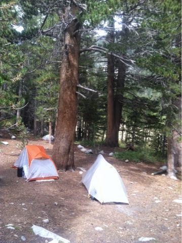
By 3pm we'd found a good campsite and set up.  There were dark clouds hanging over the pass and we decided to get chores done before it rained on us.
Looking at the pass under dark clouds from the meadow in front of our campsite.
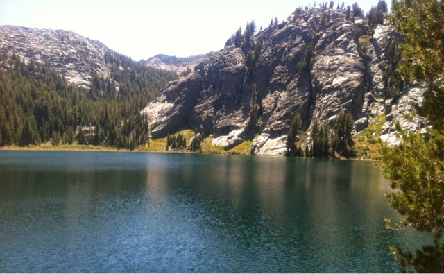
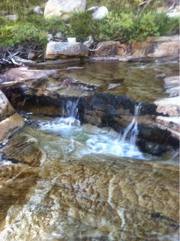
In front of camp was the Lyell Fork of the Tuolumne where we watched fish dart to and fro and had a great view of Donohue Pass and Lyell Glacier.  We filtered water from a tiny spring I found uphill from our camp and had dinner.  
There was time to explore a little before bed but it was also getting cold so once the sun went down we turned in. 
 
8/22/14. 11 miles
Last night once it turned dark I heard strange noises, couldn't figure out what they were but as I listened intently I heard pounding hooves and bells...NOT AGAIN!   Mules and horses came running up the trail then veered into the meadow at the entrance to our campsite. I looked out my tent door and in the darkness could just make out the white color on a horse.  There must have been a dozen by the sound of them.  Peggy & I wondered if they were the same group that we'd run across previously and if the ranger was still chasing them or if he'd let them go again!  If he was still working on his experiment, seeing where stock would go if let loose in a meadow, we were tired of being part of the picture!  Sometime in the wee hours of the morning they went thundering back the way they'd come.  Just our luck to get the mule treatment twice!
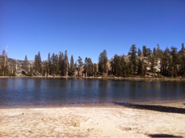
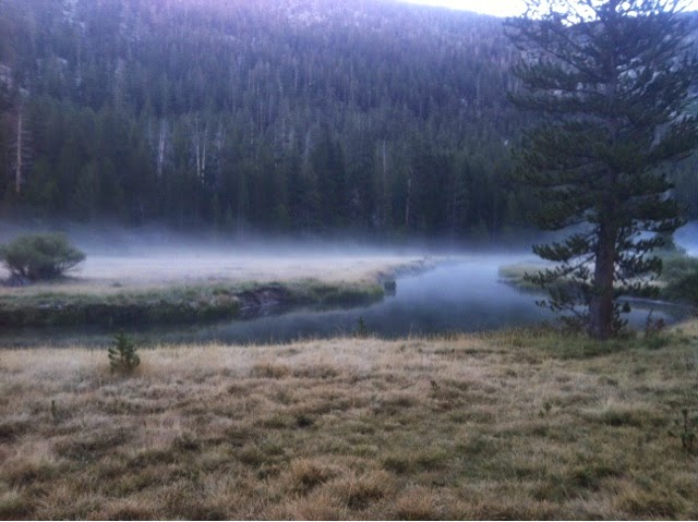
Cold mist rising off the river by our camp in the morning. It was just 1/2 mile to the end of the meadow where we saw two groups camping.  I'll bet the horses milled around the end of the meadow all night before heading back this morning.    
    We began the 4 uphill miles to the top of Donohue Pass, along the way there were two nice camps 1 and 2 miles before the top.
The first camp was beside this creek flowing off Lyell Glacier.  Climbing steeply up to the pass, I stopped to look back at the meadow where we'd spent the night.  
It was far, far down the valley.
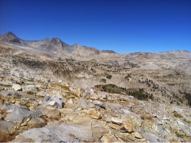
This is 2 miles up the climb, this water flows off the glacier which you can see in the peaks.  This is a tiny valley tucked below the glacier, just beautiful!  Our trail ran up the right side and behind into a small bowl before going up the left of the peaks beyond our sight.
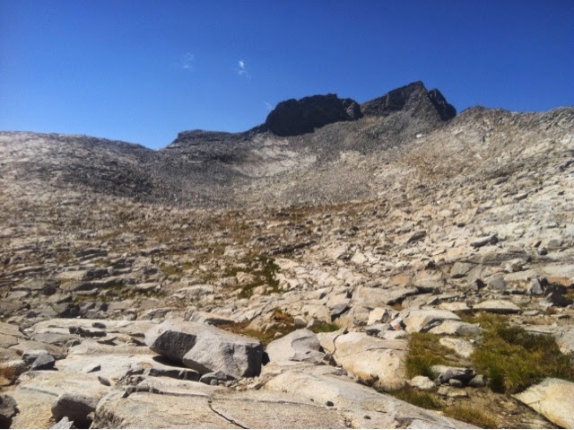
Climbing higher, looking back at the alpine bowl.  We crossed the water at the left of the photo and climbed up through the granite rocks.
Climbing higher looking back again at the alpine bowl and stream.
I'm looking at the glacier from the rocks where we took a break.  Three men on a week hike passed us on their way up the trail.
They took a photo for us at another higher, glacial colored lake with Lyell glacier in the background. This was a gorgeous place but windy and chill, we wore our jackets because it was going to get colder & windier up at the pass, 10,100 feet high.
Climbing still higher, I took this photo of the valley where we'd camped last night, a loooong way down!
Almost on top, no trees at this altitude although they are growing below where we'd taken a break.
At the summit we met a family who took our photo, the wind was howling and without my hat my hair stood on end.  Who cared as long as we'd made it to the top!!  Peggy waited for me by a tiny lake on top of the pass.  She saw birds hiding in the rocks and taking refuge by the water.  We watched them for awhile taking some photos.  They looked to me like Ptarmigan I'd seen when I lived in Alaska. They wore a grey/brown mottled coat with white feathers on feet and legs in the summer. If they were Ptarmigan they'd wear pure white feathers in the winter. (Google later confirmed that Ptarmigan had been planted in the Sierras)
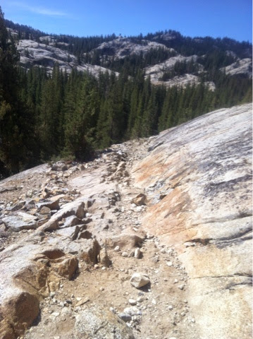
Getting down off the summit we followed a very rocky trail.  This is a look back up.  
Marmots whistled loudly from the rocks but this old guy lounged above us unmoved that we were near. 
 Looking to the left were crags and minarets in this big bowl shaped valley and more peaks to the right as well as in front. The Sierra Range is awe inspiring.  
Tiny lakes dot the landscape rimmed by sharp granite mountains.  I knew the day would hold more and more wonderful sights.  After descending for 4 miles the trail started to rise again,  Island Pass stood in the way of seeing Thousand Island Lake which I was anxious to see.  Topping the pass we wandered through small unnamed lakes as the afternoon grew chilly and breezy. 
We took a break by the shore of this gem with no name.
Then we wound across sloped meadow into the stunted trees lining the lakes. This is my first view of Thousand Island Lake. 
Coming out of the trees the lake is revealed.   Even in a low water year the sight took my breath away with its beauty.  Unfortunately the wind was ripping across the water toward us so we decided to go on to the next smaller Emerald Lake, to try for a more sheltered camp.
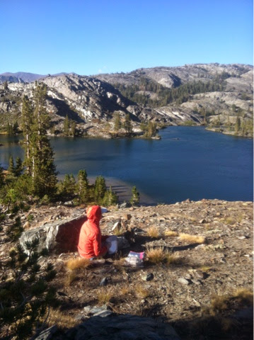
It was still windy at Emerald Lake but we found a nice campsite and called it a day. We were both exhausted.  I went exploring after setting up the tent and found we were camped on the backside of a rock cliff overlooking the lake.  We took our stoves and food up there for dinner with a $1,000 view!
Incomparable beauty!  This is why we hike.


8/20/14 Wednesday. Zero Day in Yosemite Valley

No miles hiked on the trail today.  There are no hostels or hotels in Tuolumne Meadows, no laundry or showers.  We have our resupply food packed in our packs and are required to store all edibles and 'smellables' in the bear box by our campsite because there are black bear in the area. 
After breakfast at the cafe we waited for the YART (Yosemite Area Regional Transit) bus that would take us to the valley and back for a fee.  We left our tents and some of our gear at the camp taking our packs and more expensive items with us.  The bus had cushy, comfortable seating and I enjoyed the ride down the winding road, we stopped at different campgrounds and trailheads to pick up passengers, getting to the valley at noon.  We had lunch and found places with electric outlets where we could plug in and recharge our phones, my solar charger and Peggy's Kindle while we ate and looked around the museum. 
We watched a movie about Yosemite and the Mariposa Grove of big Sequoia trees.  In the middle of the Civil War Abraham Lincoln signed a law protecting the Mariposa Grove and a small portion of Yosemite Valley.  Later it was enlarged but Lincoln began the process. I didn't know that! 
  I needed a pen for my journal  and couldn't find one for sale so Peggy yogi'd a pen for me from the sales crew. Nice!  
  We hopped a bus going to El Capitan where we found a ranger with a telescope focused on the rock face hoping to glimpse a climber that was resting on a ledge just under the nose.  We never saw the climber but the information at the site was fascinating, we could get close up views of the many routes and features on the rock face. 
El Capitan
Driving back up the winding road to Tuolumne Meadows we looked back and I caught a glimpse of El Capitan from a distance. It's the peak in the right corner of the photo. The evening light was beautiful.
Our tents were where we'd left them and darkness was falling.  Since we'd purchased sandwiches for dinner and ate on the bus we didn't have to cook.  As we were getting ready I heard someone say,  "Looky, is that you?"  I turned around and saw Candice who was camped to one side of us!  Big hugs all around, we were excited to see she'd made it to Tuolumne Meadows!  She'd arrived today and had called a friend to pick her up tomorrow, she'd hiked as far as she wanted, almost 300 miles solo!   she needed to go back to the other world where she'd gotten a job and needed to find a place to live.  We caught up as much as we could before darkness engulfed us and we stumbled back to our tents.  Tomorrow we planned to enjoy breakfast together before we set out on our separate ways.


8/18/14 Monday. Lunch at Miller Lake. 8/19/14 Tuesday. Ospreys Calling Through the Forest, 1500 mile mark, Peggy Has Hiked the Whole PCT!

8/18/14 
It was cold with white frost on the shrubs this morning.  Our first obstacle was Benson Pass at 10,100 feet as we moved away from Smedberg Lake up the granite staircase toward the pass.  
This meadow bowl was above Smedberg Lake. I'm looking back at the peak we contoured around all yesterday, happy to say goodbye to it. The sandy trail was ground granite. 
 This climb was steep and hard, it took me an hour to make the pass where 3 guys were standing looking in awe over the peaks behind me. I was so glad to get to the top I didn't stop for a picture, I wish now I had!
Down from the pass I found Peggy resting by the trail. We had a short break and again started picking our way down the rock strewn trail.  
Crossing this meadow the trail steeply ascended through forest, at last, nice, soft pine duff underfoot!  I startled a few deer on the way up, they bounded with such grace over the steep mountainside while I huffed and puffed at each step.  
  I passed a man named Jeff hiking toward Miller Lake where Peggy & I were meeting to eat lunch. He ended up stopping to take a break with us once he reached the lakeside.
Miller Lake had a nice little beach where we stopped in the shade.  Jeff, Peggy & I ended up chatting about hiking, gear and food systems.  We encouraged him to dry his own food, then he could eat what he liked instead of the prepared hiker food that didn't suit his taste.  He seemed pretty excited about new options.
About 2:30 we left the lake, moving downhill we hiked in forest, seeing big, beautiful green and black stripped rocks along the trail.  I've asked but haven't found out what type of rock this is.  
We crossed a stream and hiked beside it for awhile, it ran over granite shelves creating small waterfalls and pools. We could walk out onto the rock and look up the stream.  It was delightful!

There were still a few miles to go to camp which was along another stream so we kept moving into the adjoining Virginia Canyon to camp by Return Creek. 
We camped off trail, this is my tent in the late afternoon sun.  Behind me is the granite shelf and beyond that is Return Creek where we got water & sat looking at a pretty waterfall and pool.  We're not far from Glen Aulin and Tuolumne Meadows (both are above Yosemite Valley) where we'll hike tomorrow, we're seeing more and more people on the trail.

8/19/14 14 miles.
Wow, I was cold this morning so I started hiking when I was ready knowing Peggy would catch up with me soon enough. The trail was nice, not too steep and soft with pine and fir needles.  After about a mile I stopped because I kept hearing Ospreys calling to each other,  I wondered if there was a nest.  Stepping a little way into the forest off trail I tried to see if I could locate a nest but I couldn't see anything.  After listening for a couple of minutes I saw an osprey fly away on long wings!  I never could see the second osprey but it was cool to stand in the forest listening to them talk. Peggy joined me as the osprey flew off and we finished hiking up to the mountain top.  From there we had 5.5 miles of gradual trail down through forest 
and meadow where we noticed lots of little ground squirrels darting between rocks, standing like sentries by their burrows.  They called out a warning that intruders were in their meadow!  Later we learned the early settlers called them "picket pins" because they looked like the stakes that were once used to picket horses. 
1,500 mile mark!
Hard to believe we've logged 1500 of the 1700 miles that make up California's PCT.  Some of those miles I hiked in previous years but Peggy has done them in continuous miles this year! 
Where's the trail? 
1.5 miles of not so great trail into Glen Aulin where Peggy celebrated her personal completion of the entire PCT. She's hiked all the remaining miles in previous hikes, now I am the one who still needs to finish California.
The Tuolumne River at Glen Aulin creates a beautiful waterfall here on it's way down to Yosemite Valley. Glen Aulin is a tent resort, all amenities being furnished by mule train, guests staying in tents with stoves for warmth and a cafe that wasn't opened until 1:00 the day we got there. At the end of the season all tents get taken down and moved out by pack train. 
The Tuolumne River continues from one waterfall to another as it drops out of sight.  I'm standing on a bridge over the river.
Leaving Glen Aulin we walked beside the Tuolumne River as it ran down granite shelves providing wonderful seating for people to picnic.  We began to see lots of people with packs, day hiking or week hiking. We once again played the game of identifying the smells,  Tide? Deodorant? Perfume? Wow, definitely lots of perfume!  
Tuolumne Meadows Resort was our destination, 6 miles away, so our new goal was lunch at the cafe!
These clouds began to gather, we hoped no rain was in the near future.
Granite hillsides glared in the bright sun,  worn smooth by glacial action. 
The Tuolumne River followed the trail for awhile, the Sierras are in the background.  
When we arrived at Tuolumne Meadows near Hwy 120 there were loads of people and traffic, quite a change from our life on trail. We navigated highway traffic and crowds then found the Post Office, store and cafe where there were rules for everything.  We waited in line (per instructions) for our resupply boxes and unpacked them (per instructions) at a specific picnic table throwing our cardboard in a specific place.  When we had lunch it started to rain but only for a few minutes.  We hiked back to the campground for walk-in campers and set up tents for the night.  We wanted a zero day tomorrow, 8/20/14.  Our plan was to get breakfast then catch the YART bus at 10am to Yosemite Valley to see the sights.  We plan on camping again tomorrow night and leaving 8/21/14 for Donohue Pass and Red's Meadow.
Finally I had cell service so I called home to make plans for Robin to pick us up on 8/24/14 at Red's Meadow in 3 days.